 Aero Sync

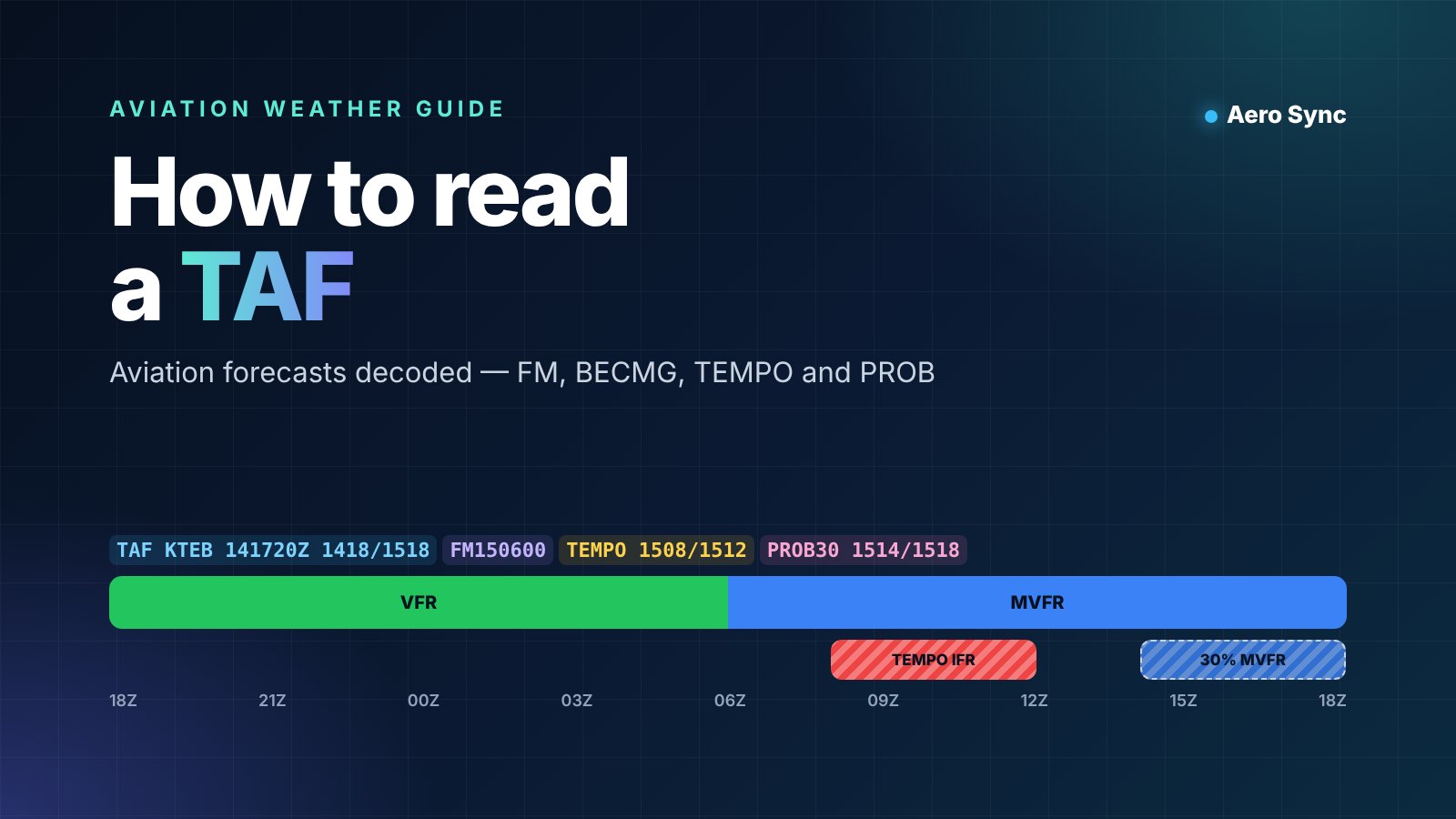
A METAR tells you what the weather is doing now. A TAF tells you what it is expected to do over the next day or more, and that is what flights are planned on. This guide shows you how to read a TAF step by step: the header, the base forecast and the four change groups that confuse most people. It finishes with how professional crews use TAFs to choose alternates.
Read this first: a TAF uses the same codes as a METAR for wind, visibility, weather and clouds. If any of those are new to you, start with our guide on how to read a METAR. This article focuses only on what is different in a TAF.
What is a TAF?
TAF stands for terminal aerodrome forecast. It is a professional weather forecast for one airport, written by a meteorologist. In the United States, a TAF covers the area within 5 statute miles of the centre of the runways. Weather between 5 and 10 miles away is marked with VC, for "in the vicinity".
Most TAFs are issued four times a day, around 00, 06, 12 and 18 UTC. Each one is usually valid for 24 or 30 hours. Busy international airports tend to have 30-hour TAFs, which helps long-haul flights plan their arrival.
Not every airport has a TAF. Smaller airfields without one rely on nearby airports, area forecasts and their own METARs. If your destination has no TAF, plan with extra care.
How is a TAF different from a METAR?
| METAR | TAF | |
|---|---|---|
| What it is | An observation of the weather now | A forecast for the coming hours |
| How often | Usually every hour | Usually every 6 hours, plus amendments |
| Time covered | One moment | A validity period, often 24–30 hours |
| Change groups | Short trend at some airports | FM, BECMG, TEMPO and PROB |
| Temperature and pressure | Temperature, dew point and altimeter setting | Usually none; some countries add maximum and minimum temperature |
How to read a TAF header
Every TAF starts with a short header that tells you which airport, when it was written and which hours it covers. Getting this right prevents the most common mistake: using an old or wrong forecast.
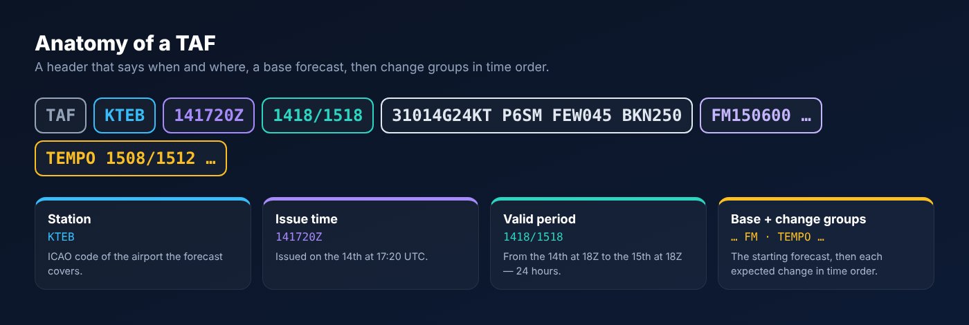
- TAF marks the report type. TAF AMD means an amended forecast that replaces the previous one. TAF COR means a correction.
- KTEB is the ICAO code of the airport, here Teterboro.
- 141720Z is the issue time: the 14th of the month at 17:20 UTC.
- 1418/1518 is the validity period: from the 14th at 18:00 UTC to the 15th at 18:00 UTC.
The validity period uses day and hour only, with no minutes. You may see "24" as an hour, as in 1424. It simply means midnight at the end of the 14th, the same as 1500.
The base forecast
Right after the header comes the base forecast. It describes the conditions expected at the start of the period, using the same wind, visibility, weather and cloud codes as a METAR.
In our example, 31014G24KT P6SM FEW045 BKN250 means wind from 310° at 14 knots gusting 24, visibility more than 6 miles, a few clouds at 4,500 feet and a broken layer at 25,000 feet. The P in P6SM means "plus": more than 6 statute miles, the highest value US TAFs use.
A few codes appear in TAFs more often than in METARs:
- NSW means "no significant weather". It cancels rain, snow or fog from an earlier group.
- WS020/27055KT warns of low-level wind shear: at 2,000 feet the wind is from 270° at 55 knots. US TAFs use it for non-thunderstorm wind shear.
- TX18/1412Z TN09/1504Z gives the forecast maximum and minimum temperatures and when they occur. Many countries outside the US include it.
What do FM, BECMG, TEMPO and PROB mean?
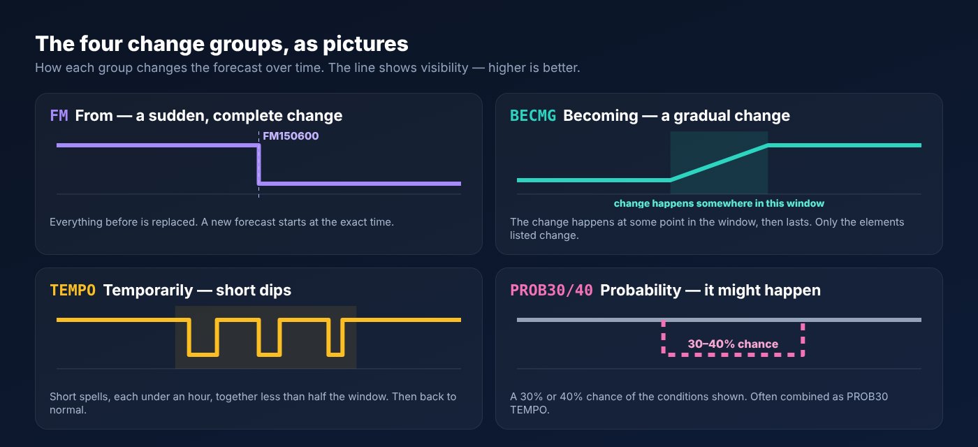
Change groups are the heart of a TAF. Each one starts with a code that tells you how the weather will change, followed by when. Read them in order and the forecast becomes a timeline.
FM — from
FM150600 VRB04KT 3SM BR BKN012 means that from 06:00 UTC on the 15th, a completely new forecast applies: variable wind at 4 knots, 3 miles visibility in mist and a broken ceiling at 1,200 feet. Everything in the previous forecast is replaced, including anything not repeated. FM is the change group most used in US TAFs.
BECMG — becoming
BECMG 1410/1412 05018G28KT means that sometime between 10:00 and 12:00 UTC on the 14th, the wind will change to 050° at 18 knots gusting 28. Only the elements listed change. Visibility and cloud stay as before. The change can happen at any point in the window, so plan for both the old and new conditions during it. BECMG is common in ICAO-style TAFs and rare in the US.
TEMPO — temporarily
TEMPO 1508/1512 1SM BR OVC006 means that between 08:00 and 12:00 UTC on the 15th, visibility will temporarily drop to 1 mile in mist with overcast cloud at 600 feet. Each spell is expected to last less than an hour, and together they cover less than half of the period. Between the spells, the main forecast applies.
PROB30 and PROB40 — probability
PROB30 1514/1518 3SM -TSRA BKN020CB means there is a 30% chance of a light thunderstorm with rain, 3 miles visibility and cumulonimbus at 2,000 feet between 14:00 and 18:00 UTC. ICAO allows 30% and 40%. US forecasters use only PROB30, and not in the first nine hours of the TAF. You may also see PROB40 TEMPO, which combines the two: a 40% chance of temporary conditions.
| Group | Meaning | Lasting? | How to use it |
|---|---|---|---|
| FM | Rapid, complete change at an exact time | Yes, until the next FM | Start a new forecast from this time |
| BECMG | Gradual change within a window | Yes, after the window | Expect either condition during the window |
| TEMPO | Short temporary changes | No, under an hour each | Be ready for the worse conditions at any time |
| PROB30 / PROB40 | 30% or 40% chance | Possible | Weigh the risk, especially near your ETA |
Read a TAF as a timeline, not a sentence: find your arrival time, then check every group that touches it.
How to read a TAF hour by hour
The fastest way to understand a TAF is to lay it out on a timeline. Try it with the decoder below. Choose an example, or paste any real TAF, then drag the ETA slider. The colours follow the standard flight categories used by the Aviation Weather Center: green VFR, blue MVFR, red IFR and magenta LIFR.
Look at the Teterboro example. The evening starts VFR. From 06:00 UTC the forecast changes to MVFR in mist, with temporary IFR between 08:00 and 12:00. In the afternoon a new FM group improves the weather, but there is a 30% chance of thunderstorms. A flight arriving at 09:00 UTC faces a very different airport from one arriving at 19:00 the evening before.
Worked example: reading an ICAO-style TAF
US TAFs lean on FM groups. Most of the world uses BECMG and TEMPO more often. Here is a typical ICAO-style forecast for Istanbul Airport, read group by group.
TAF LTFM 140500Z 1406/1512 03012KT 9999 FEW035 TX18/1412Z TN09/1504Z BECMG 1410/1412 05018G28KT TEMPO 1414/1418 4000 -SHRA BKN014 PROB30 1420/1502 0800 FG VV002 BECMG 1503/1505 VRB03KT 9999 NSW SCT025
- Header: issued on the 14th at 05:00 UTC, valid for 30 hours from 06:00 on the 14th to 12:00 on the 15th.
- Base forecast: wind 030° at 12 knots, 10 km or more visibility and a few clouds at 3,500 feet. The maximum temperature of 18 °C is expected at 12:00 UTC and the minimum of 9 °C at 04:00 the next day.
- BECMG 1410/1412: between 10:00 and 12:00 the wind picks up to 050° at 18 knots, gusting 28. Visibility and cloud do not change.
- TEMPO 1414/1418: in the afternoon, short spells of 4,000 m visibility in light showers, with a broken ceiling at 1,400 feet.
- PROB30 1420/1502: overnight there is a 30% chance of fog, with 800 m visibility and the sky obscured at 200 feet. That is LIFR.
- BECMG 1503/1505: early on the 15th the wind becomes light and variable, the visibility returns to 10 km or more, any weather ends (NSW) and there are scattered clouds at 2,500 feet.
The lesson: a daytime arrival looks easy apart from gusty crosswinds and passing showers. A night arrival carries a real risk of fog. That one PROB30 group could be the reason to carry extra fuel or choose a different alternate.
How do pilots use a TAF for flight planning?
Pilots and dispatchers do not read the whole TAF equally. They focus on the hours around the estimated time of arrival (ETA) at the destination and at any alternate airport.
Check the ETA window
Look at every group that applies from at least one hour before to one hour after your ETA. If a TEMPO or PROB group overlaps that window, treat it seriously. A temporary drop to 600 feet can make the difference between landing and diverting.
Decide if you need an alternate
In the United States, the rule for IFR flights is often called the "1-2-3 rule". Under 14 CFR 91.169, you can skip filing an alternate only if, from 1 hour before to 1 hour after your ETA, the forecast shows a ceiling of at least 2,000 feet and visibility of at least 3 miles. The destination also needs a published instrument approach.
The alternate itself must meet minimums at your ETA there. If no special minimums are published, the standard values are a 600-foot ceiling and 2 miles visibility for a precision approach, or 800 feet and 2 miles for a non-precision approach. Commercial operators, and operators in Europe and other regions, follow their own rules. Those rules often say exactly how to treat TEMPO and PROB groups when choosing an alternate.
Tip: always compare the TAF with the latest METAR before departure. If the airport is already worse than forecast, the TAF may be too optimistic. Expect an amendment and plan a stronger alternate.
Watch for amendments
Forecasters issue an amended TAF (TAF AMD) when the weather differs significantly from the forecast. Before every flight, and again before descent on long trips, make sure you are using the latest version.
What is different in US and ICAO TAFs?
The structure is the same everywhere, but local practice differs. If you fly internationally, these differences matter.
| United States | Most other countries (ICAO) | |
|---|---|---|
| Visibility | Statute miles, up to P6SM | Metres, up to 9999 (10 km or more) |
| Main change group | FM | BECMG and TEMPO, plus FM |
| Probability | PROB30 only | PROB30 and PROB40 |
| CAVOK | Not used | Used for ceiling and visibility OK |
| Wind shear | WS group for non-convective wind shear | Usually not included |
| Temperatures | Not included in civil TAFs | TX and TN often included |
For official definitions, see the weather chapter of the FAA Aeronautical Information Manual. You can read live TAFs for any airport at the Aviation Weather Center.
Common TAF mistakes: treating a TEMPO as the main forecast or ignoring it completely; reading BECMG as an instant change; forgetting that times are UTC and include the day of the month; using a TAF after an amendment has been issued; and applying an airport's TAF to a different airfield nearby.
Key takeaways
- A TAF is a forecast for one airport, usually valid for 24–30 hours.
- The header gives the station, issue time and validity period in UTC.
- FM is a complete new forecast, BECMG a gradual change, TEMPO short spells and PROB a 30–40% chance.
- Always check every group from 1 hour before to 1 hour after your ETA.
- Compare the TAF with the latest METAR and look for amendments.
How to read a TAF faster with Aero Sync
Decoding TAFs by hand is a core skill, but in daily operations speed matters. The Aero Sync Aviation Weather tool fetches the live TAF and METAR for any airport and decodes every group into plain language. It shows the flight category for each forecast period, adds headwind and crosswind for every runway and nearby station reports, and exports a clean PDF briefing for crews or clients.
New to weather reports? Start with our step-by-step guide on how to read a METAR, then come back to this one.
Decode TAFs free with Aero Sync
Frequently asked questions
What is a TAF in aviation?
A TAF, or terminal aerodrome forecast, is an official weather forecast for a single airport. It covers wind, visibility, weather and cloud for the next 24 to 30 hours and is used to plan flights.
How often are TAFs issued?
Most TAFs are issued four times a day, around 00, 06, 12 and 18 UTC. Forecasters also issue amended TAFs at any time when the weather changes significantly.
How long is a TAF valid?
Most TAFs are valid for 24 hours. Many larger international airports issue 30-hour TAFs. The exact period is shown in the header, for example 1418/1518.
What does TEMPO mean in a TAF?
TEMPO means temporary fluctuations. The conditions are expected in spells of less than one hour, which together cover less than half of the stated period.
What does BECMG mean in a TAF?
BECMG means becoming. The listed conditions are expected to develop gradually during the stated window and then continue. Only the elements listed change.
What does FM mean in a TAF?
FM means from. It starts a completely new forecast at the exact time given, such as FM150600 for 06:00 UTC on the 15th. All earlier conditions are replaced.
What does PROB30 mean?
PROB30 means there is a 30% probability of the conditions shown during the stated period. PROB40 means a 40% probability. US TAFs use only PROB30.
What is the difference between TEMPO and PROB?
TEMPO says the conditions are expected, but only for short spells. PROB says the conditions may or may not happen, with a 30% or 40% chance. PROB40 TEMPO combines both.
Are TAF times in local time or UTC?
TAF times are always in UTC, also called Zulu time. The day of the month comes first, so 1508 means the 15th at 08:00 UTC.
What does TAF AMD mean?
TAF AMD is an amended forecast. It replaces the previous TAF because the weather differs from what was forecast. Always use the latest version.
Do all airports have a TAF?
No. TAFs are usually issued for larger airports with regular weather observations. Smaller airfields may have only a METAR or no report at all.
What is the 1-2-3 rule?
In the US, an IFR flight does not need an alternate if, from 1 hour before to 1 hour after the ETA, the destination forecast shows a ceiling of at least 2,000 feet and visibility of at least 3 miles. The destination must also have an instrument approach.